We picked a freezing cold day for this walk between Christmas and New Year. The original plan for the day was Warwick Castle but as we have the Merlin Essentials pass this year this date was unfortunately one of our restricted days so we had to have a re-think.
The walk started at the National Trust car park for the Longshaw Estate of which Padley Gorge is a feature. The postcode for this is S11 7TZ – it is on Owler Bar Road. There is other parking in the area just along from here (near the Fox House pub where Owler Bar Road joins Hathersage Road) that is free but the area was quite busy when we arrived (at around 9.30am) so we grabbed a space in the car park rather than risk driving further away. The parking was £8 for the whole day which can be paid on the machine or inside the gift shop. There is also a shorter stay option of £5 for 4 hours but we didn’t want to risk not getting back within that time frame (spoiler alert -we could in fact have paid for the four hour option!)
There are three National Trust signposted walks that start from this car park and are categorised as short, medium and long, Our route was chosen from All Trails and followed the National Trust medium walk for part of the way.
To start, follow the pathway past the shop which leads you to a cafe/restaurant area which also has toilets – preferable to a wild wee in this weather!
Just after the cafe area we turned left and walked towards the pond. The All Trails app allows you to see the route offline and without a subscription however we did make a couple of mistakes on this route due to it not being that clear from the surrounding paths in parts.
After looping around behind the pond a short path brings you to Granby Barn which has information on what the area was previously used for and a guide to the landscape that can be seen from that viewpoint. There is also information about birdlife in the area.
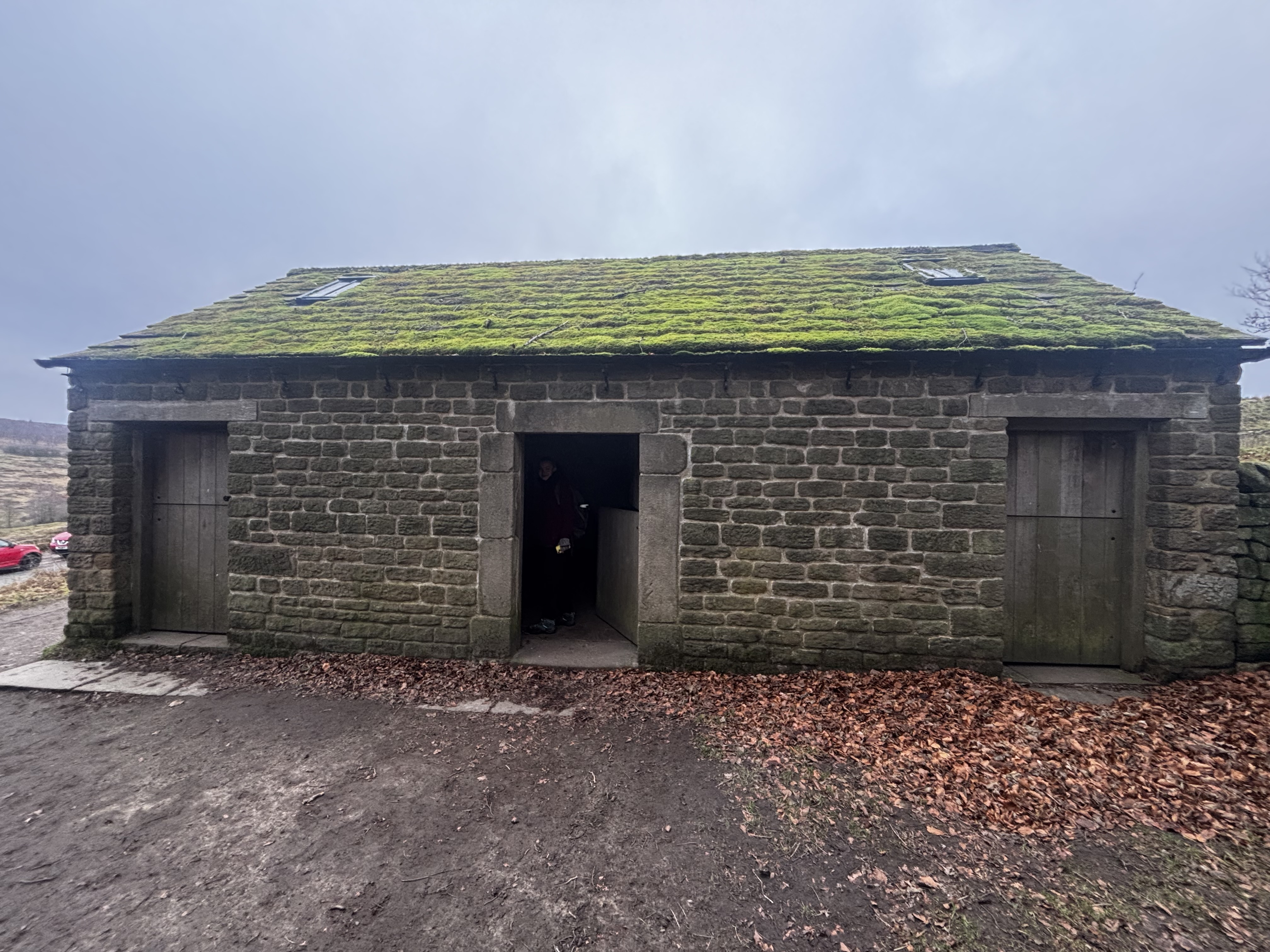
The Padley area consists of Padley Gorge, Padley Wood and Padley Manor. The gorge has been carved into the valley by Burgage Brook which used to form the border between Derbyshire and Yorkshire but now follows the path of the Hathersage Road. The surrounding landscape was once home to several quarries (now abandoned) which mined the millstones that were abundant in the area.
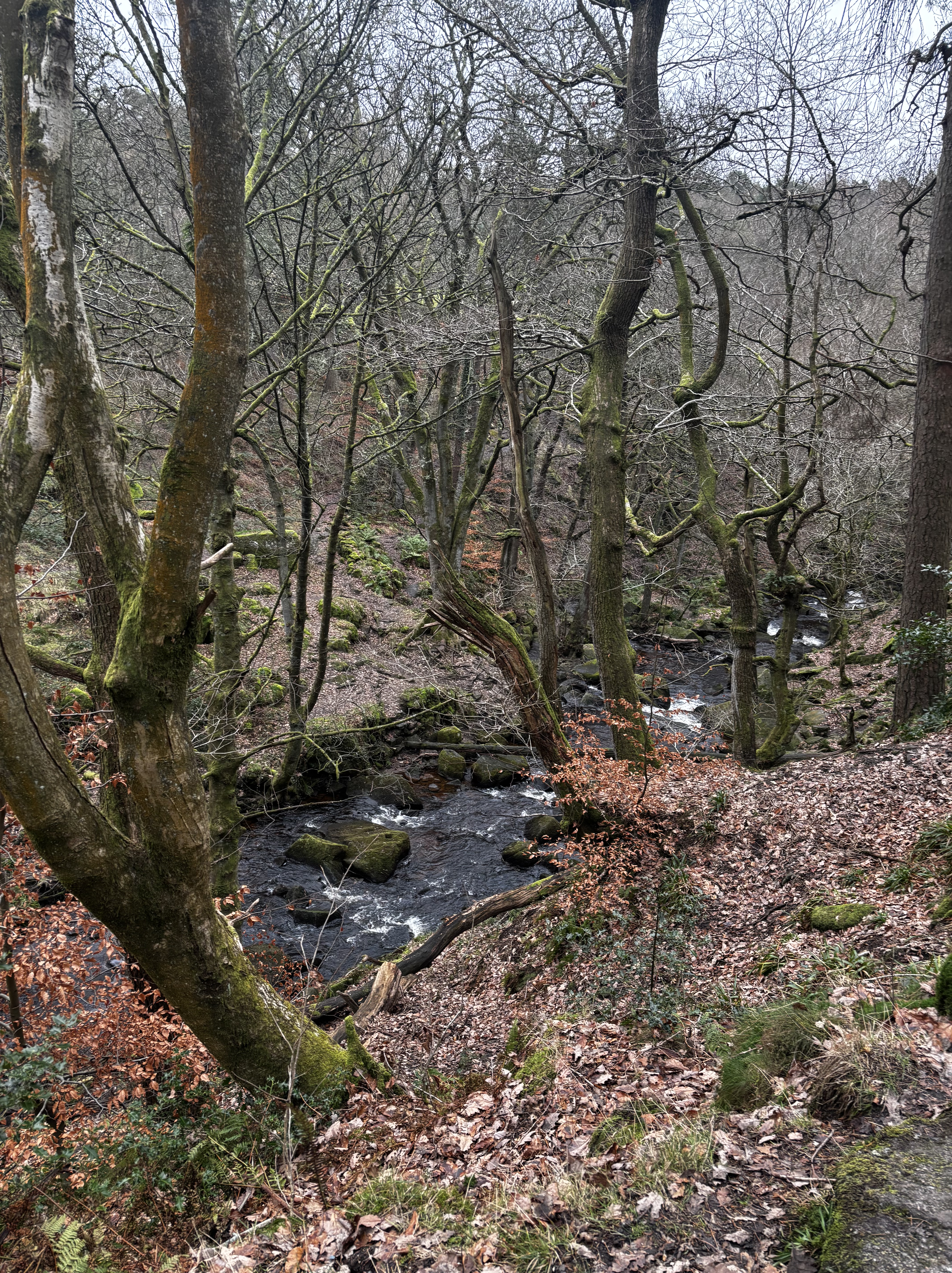
From the information shed, we crossed the road and walked into a picturesque area with water streams and several paths running through it. We had a bit of confusion here with which trail we were following and ended up crossing a bridge we shouldn’t have and having to double back but this was probably only a about five minutes out of the way. We crossed back to be on the right hand side of the water and carried on deeper into a scenic woodland area.
There were several dog walkers in this area with dogs off lead that were running around people’s feet, which was quite dangerous on the slippy, uneven ground so we had to be extra cautious as we made our way through this area.
The ancient woodland part is stunning and feels almost magical with its green moss covered rocks and bold autumnal colours. As the woodland area opened out we came across a giant piece of stone that resembled a bed and presented us with an excellent photo opportunity. Once the path opened up a little more and split from the National Trust guided route, the concentration of people thinned out considerably and we were less troubled by the unruly (but very cute!) dogs.
Along the route you may spot trees or logs that have coins embedded in them. This practice comes from an ancient Pagan tradition where coins are hammered into trees to allow one to make a wish, bring good luck, or rid oneself of an illness.
This part of the walk is just behind Grindleford Railway Station which is part of the Hope Valley line between Manchester and Sheffield. The track runs parallel to the walking trail for a short time.
A little over an hour into the walk brought us to Padley Manor. The building there is what was once the original gatehouse, and contains the chapel which is still in use. It wasn’t open when we passed (it opens after Easter each year) but we paused to have a look at the outside of the building and read the information board. The Chapel was once used to hide Catholic Priests who were being persecuted for their views. Two were caught here in 1588 and subsequently executed. The Fitzherbert family who owned the house at the time and were arrested for their part in hiding the priests, buried their altar stone in the garden to avoid detection. This was discovered centuries later in 1934 and was returned to its rightful place in the chapel.
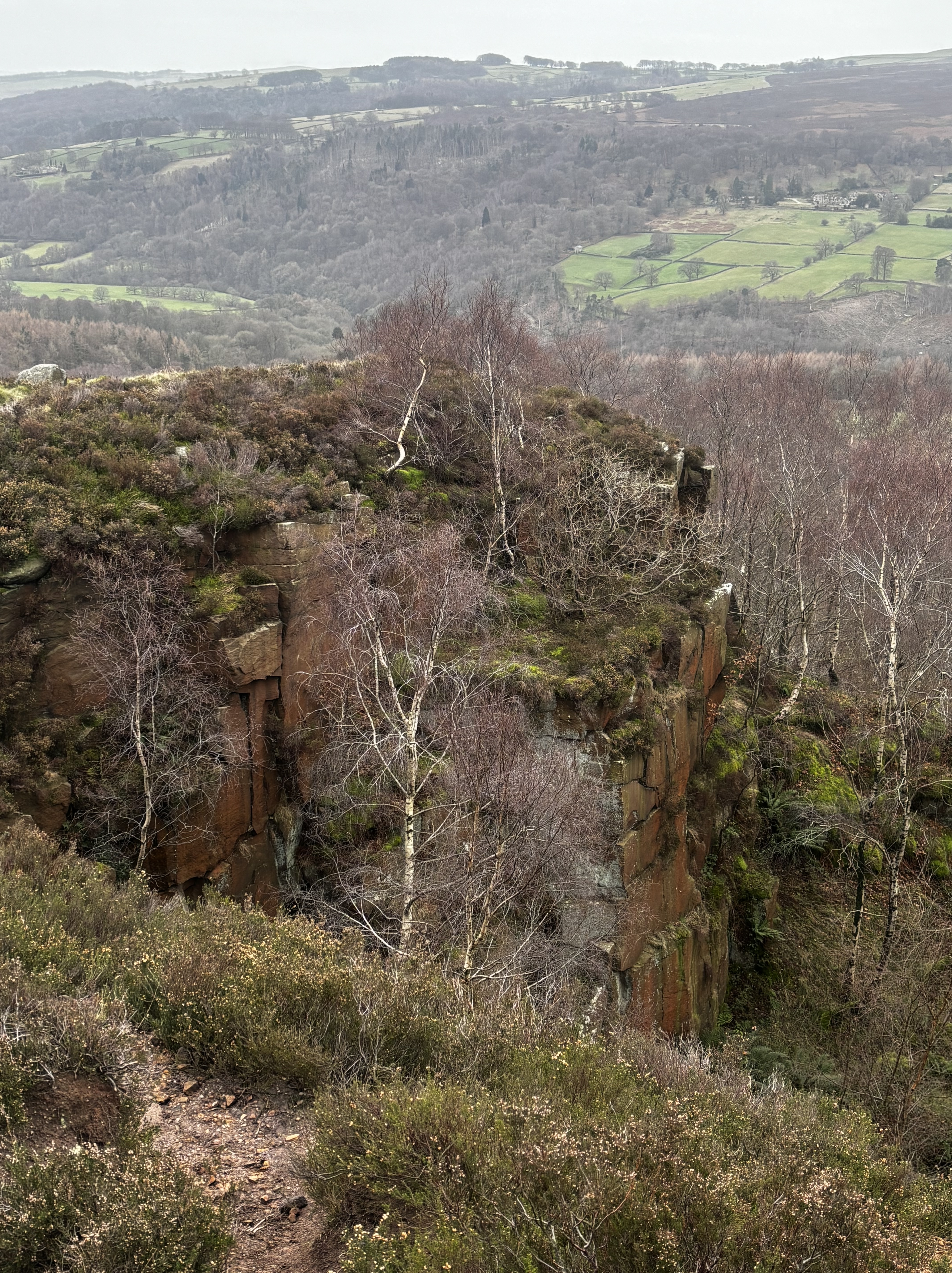
The walk from here was on much more exposed paths with some stunning views of the surrounding countryside, Hathersage and beyond. We saw a lot of people bird watching around this area too.
We eventually reached a main road (the A6187) which you have to cross to then walk up a smaller road – Ringinglow Road – for a short time until reaching a large gate on your right hand side. To the right of the large gate there is a smaller gate. As the large gate did not appear to open, we initially took the path through the smaller gate which takes you into a small wooded area. This was incorrect. We luckily realised quickly (due to seeing other people take the correct route) that we needed to to return to the gate that doesn’t open and climb over the stile that was next to it – dogs and children would have to be lifted over.
Beyond the gate the walk turns quite steep on very uneven terrain as you ascend towards Millstone Edge. (Word of advice- don’t try to hold on to the fence for support – it has barbed wire in parts!) This area was quite busy with people taking their lunch and enjoying the stunning views. We walked a little further on and found a rock to sit on and eat our sandwiches. It was so cold that I could only stand to take my gloves off for a very short time to eat! I would advise planning a break in a less exposed part of the path if its a particularly cold or windy day. The views were excellent though!
We kept moving to keep warm on the exposed paths and found ourselves travelling slightly back downhill across a wide open area with multiple paths carved and lots of gorse and similar shrubbery. I haven’t taken many photos during this part but would estimate we walked for a further 20-30 minutes before reaching another really pretty area where the brook was running through in much wider sections than we had seen before. This looked a great area for dogs to test the water! There are a couple of bridges across the brook that allow for good viewpoints and photographs.
From this area it was around 10-15 minutes walk back to the start of the route behind the visitor centre and cafe. Toilets and a hot drink were very welcome by this point! This area was very busy at this time so there was a bit of a queue for drinks and snacks.
The walk took us three hours and fifteen minutes in total which included maybe ten minutes for sitting down to eat. Very enjoyable even in the cold weather and not particularly challenging terrain so a good one for all ages and abilities.
We found out afterwards that there are three hidden tunnels in the area that walkers often try to see, so we will definitely be returning to the area to try and spot these!

Leave a comment